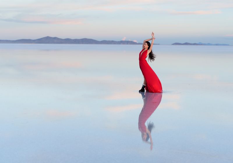
At 10,582 km² — roughly the size of Jamaica — Salar de Uyuni is the world’s largest salt flat. At 3,656 m above sea level, it exists in a category of its own: a vast, blinding-white expanse where the horizon disappears and the sky doubles in the surface below you.
Geology and Lithium
The Salar is a prehistoric lake bed. When the ancient inland sea (Lago Minchin) evaporated approximately 30,000 years ago, it left behind a salt crust up to 10 m thick. Below the crust lies a lithium-rich brine lake.
Bolivia’s Salar holds an estimated 50–70% of the world’s known lithium reserves — a resource that has become central to electric vehicle battery production. The Bolivian state controls exploitation through YABOG (Yacimientos de Litio Bolivianos).
NASA uses the Salar’s extraordinary flatness — less than 1 m of altitude variation across the entire 10,000 km² surface — to calibrate the altimeters of Earth-observing satellites.
The Mirror Effect
The Salar’s most famous phenomenon requires a precise set of conditions:
- Rainy season timing: November–March, when rainfall floods the flat
- Water depth: 2–5 cm — enough to create reflection, not so deep it becomes a lake
- Wind conditions: Early morning, before wind creates ripples
- Peak period: January and February, when rainfall is most consistent
The hexagonal salt patterns visible in the dry season (May–September) are an entirely different but equally photogenic experience.
Wildlife
Flamingos: Three species breed at the Salar’s edges and at Laguna Colorada (346 km southwest). Andean flamingos peak November–March during breeding season.
Incahuasi Island: Giant cacti (Echinopsis atacamensis) up to 10 m tall and estimated 1,200 years old rise from the centre of the flat. The island is also home to viscachas (Andean rabbit-chinchilla hybrids) and occasional condors overhead.
Tours
Day trip ($30–50): Northern salt flat, Incahuasi Island, Train Cemetery, salt hotel lunch. Covers a small fraction of the flat.
3-day southwest circuit ($70–120 shared): Adds Laguna Colorada (three flamingo species), Sol de Mañana geysers, Laguna Verde at the Chilean border, and Eduardo Avaroa Reserve. This is the recommended option.
Private 3-day ($250–400): Same circuit with a dedicated vehicle and guide.
Train Cemetery: On the outskirts of Uyuni town, this rusting field of 19th-century British locomotives was abandoned when the mining boom ended. Free to enter, easily combined with a salt flat day trip.
Stargazing
The Salar offers some of the best stargazing in the world — zero light pollution, 3,656 m altitude, and extreme dryness. The Milky Way core is visible April–September. Several operators offer dedicated night photography tours.
Key facts
- → Salar de Uyuni covers 10,582 km² at 3,656 m altitude — larger than the US state of Connecticut.
- → The salt crust is approximately 10 m thick and rests above a lithium brine lake estimated to contain 50–70% of the world's known lithium reserves.
- → The mirror effect requires 2–5 cm of rainwater and occurs November–March; peak conditions are January–February at dawn.
- → NASA uses the Salar's flatness — less than 1 m altitude variation across 10,000 km² — to calibrate satellite altimeters.
- → Incahuasi Island hosts giant cacti up to 10 m tall and 1,200 years old at the centre of the salt flat.
Frequently asked questions
When is the best time to visit Salar de Uyuni? +
For the mirror effect: January–February (rainy season peak). For clear blue skies and hexagon salt patterns: May–September (dry season). The flat is accessible year-round; the experience is different but not lesser in the dry season.
How do I get from La Paz to Uyuni? +
By night bus (10–11 hours, $12–20) or by flight to Oruro or directly to Uyuni (BoA/Amazonas, 45–60 minutes, $80–120). Most travellers take the night bus from La Paz terminal. From Sucre, buses take 4–5 hours.