Bolivia has a problem with photography, and the problem is that it is too spectacular. You arrive at Uyuni and the sheer whiteness of the salt flat overexposes every shot. You arrive at Laguna Colorada at 4,300 meters with flamingos in the foreground and a volcano behind them and you freeze instead of adjusting your settings. Here are the locations, what to photograph, and how to do it properly.
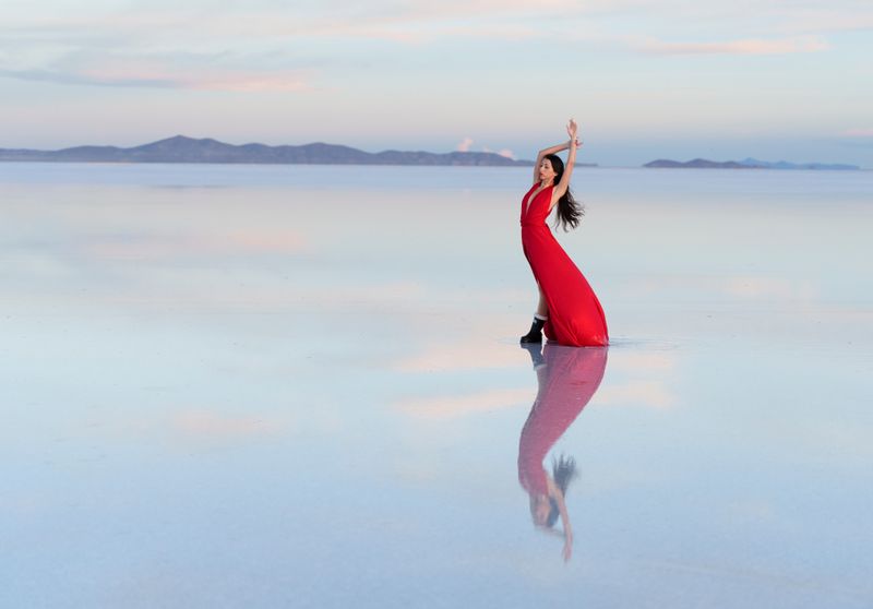
1. Salar de Uyuni: the mirror effect
The mirror photograph — the one where salt flat meets sky in a perfect reflection — requires a specific set of conditions. You need 2 to 5 centimeters of standing water on the flat, which occurs reliably between November and March (rainy season). Too little water gives you wet salt with no reflection. Too much gives you a lake with waves.
The mirror is photogenic throughout rainy season, but the absolute peak is January and February. The water is there, the skies are dramatic, and sunrise on the flat produces the kind of image that makes people ask what filter you used (the answer is none — Bolivia genuinely looks like that).
Settings: Expose for the sky, not the foreground. At sunrise, this typically means metering off the mid-horizon. A CPL (circular polarising filter) reduces glare and deepens the sky. A tripod is essential for pre-dawn work. Shoot in RAW — the latitude is useful for recovering blown highlights in the sky.
Logistics: You need to be on the flat before sunrise, which means sleeping in Uyuni town and leaving at 4:30 to 5:00am. Most Uyuni tour operators offer this option; negotiate it explicitly before booking.
During dry season, the water is gone but the hexagonal salt crust is exposed in geometric patterns that photograph beautifully in early-morning side-light. The perspective-play photographs (playing with scale and distance using objects or people) work year-round.
2. Laguna Colorada: flamingos at 4,278m
The blood-red lagoon in Eduardo Avaroa Reserve is visited on day two of the standard southwest circuit tour. Three flamingo species are present: James’s, Andean and Chilean. The James’s flamingo is the rarest — deep pink, carmine wing markings, yellow-tipped red bill.
Settings: You need a telephoto. Flamingos at Colorada are rarely within 50 meters of the shore, so 200mm is a minimum; 400mm preferred on a full-frame body, or the equivalent on a crop sensor. Use a fast shutter speed (1/1000s or above) to freeze wing movement. The high altitude and extreme UV means overexposure is easy — dial in -0.7 to -1 EV from metered exposure and bracket.
Timing: Early morning. By 10am the wind rises and the flamingos move to sheltered feeding zones away from the photographic angles. Be at the lake by 7:30am.
3. Laguna Verde and the Altiplano color palette
Three hours beyond Colorada on the southwest circuit, at 4,380 meters near the Chilean border, Laguna Verde is green — genuinely, intensely green — from dissolved magnesium, calcium, lead and arsenic salts. Behind it rises the Licancabur volcano at 5,920 meters, perfectly cone-shaped.
The photography challenge here is framing: the lagoon is wide and the volcano’s proportions look compressed in a standard wide shot. Use a medium telephoto (70–100mm) to bring the volcano closer to the lake in the frame. Morning is best; afternoon the light comes from behind the volcano.
4. Sol de Mañana geysers
On the same southwest circuit, at 4,850 meters, the Sol de Mañana geysers erupt in columns of sulphurous steam at dawn. The light, the steam, the otherworldly scale — it is one of Bolivia’s most striking images.
Settings: Use a moderately wide angle (24–35mm). The steam moves quickly; 1/250s or faster stops it into interesting shapes. A lens hood helps with the condensation that coats your front element.
Warning: Stay on marked paths. The ground is thin crust over boiling mud. People have died here.
5. Valle de la Luna, La Paz
Fifteen minutes from Miraflores, at 3,300 meters, Valle de la Luna is a maze of eroded clay pinnacles, some reaching 15 meters, sculpted by rain on an ancient lakebed. The miniature-landscape effect invites wide-angle distortion and experiment.
Timing: Late afternoon — the gold light from the west hits the peaks and turns the grey clay a warm orange. Arrive by 4pm and stay until closing.
6. Death Road: landscape over action
The old North Yungas Road descends from 4,650 meters to 1,200 meters in 64 kilometers of unpaved cliff-edge road. If you are biking it as a tourist, your camera will be in the bag. If you are driving or photographing the bikers from the road, the views of cloud-hung jungle canyon are extraordinary.
Settings: The descent passes through multiple vegetation zones. At altitude: clear skies, brown grass, snow on peaks. By kilometer 30: cloud forest, epiphytes, waterfalls appearing on the cliff face. A wide angle captures the road curvature and the void. A telephoto isolates riders against the jungle backdrop.
7. Sajama volcano
Nevado Sajama at 6,542 meters is Bolivia’s highest peak, visible from the Oruro–Chile highway crossing the Altiplano. The village of Sajama (4,200 m) allows access to hot springs with the volcano as backdrop — surreal combination.
The photograph: Hot springs pool foreground, Sajama reflected in the water behind. Works at dawn or dusk when the volcano glows pink.
8. Colonial Sucre and Potosí
Sucre’s white colonial architecture photographs beautifully from the church towers — particularly from the campanile of San Felipe Neri, which offers a rooftop view of the city’s domed churches against mountain backdrop. Permission is sometimes required (small donation at the church).
Potosí: Cerro Rico dominates the skyline, a constant red-brown cone above the city’s baroque architecture. The most powerful image is the mountain from the market streets in the foreground — poverty and an industrial scar from 500 years of mining, visible in a single frame.
9. Rurrenabaque: wildlife and jungle light
Wildlife photography in the Pampas del Yacuma and Madidi jungle requires patience and a fast telephoto. The subjects — pink dolphins, caimans, capybaras, giant otters, macaws — are active at dawn and dusk. A 100–400mm zoom is the practical choice; a 500mm prime is ideal but impractical in canoe logistics.
Settings: f/5.6–8, ISO 800–3200 in forest shade, continuous autofocus for moving animals. The jungle light is beautiful and low — you will need to push ISO more than you expect.
10. Tiwanaku: pre-Inca stone
The Tiwanaku site at 3,841 meters, 70 km west of La Paz, contains the semi-subterranean temple with carved stone heads, the Puerta del Sol (Gate of the Sun), and monumental carved stone figures. Photography here is about detail — the carved faces on the Kalasasaya temple walls, the astronomical alignment of the Puerta del Sol at sunrise.
Timing: Arrive at opening time (9am) before tour buses. The site faces east; morning light works for the Puerta del Sol.
Practical photography notes for Bolivia
- UV at altitude destroys white highlights. Underexpose by 0.5–1 EV as your starting point. Check your histogram after every shot until you learn the light.
- Cold destroys batteries. At 4,000+ meters in winter, batteries die in 30 minutes in camera bags. Keep spares in an inner pocket against your body.
- Altitude affects focus accuracy on older autofocus systems due to air density. Manual-check focus at critical shots.
- Dust on the Altiplano gets into everything. A rocket blower and lens cloth are not optional.
- Ask before photographing people. In markets and communities, ask. Many people are photographed a hundred times a day and deserve that courtesy. If someone declines, respect it.
- Drone regulations: Bolivia requires drone registration and permits for commercial use. Recreational drone use is loosely regulated but prohibited in national parks. Check current DGAC (Bolivia’s civil aviation authority) regulations before bringing a drone.
Key facts
- → Salar de Uyuni covers 10,582 km² at 3,656 m — the world's largest salt flat; mirror effect requires 2–5 cm water depth (November–March).
- → UV radiation at 3,500–4,500 m in Bolivia is among the world's highest; overexposure by 1–2 stops is the most common photography error.
- → Laguna Verde (green colour from magnesium, calcium, lead) and Laguna Colorada (red from Dunaliella salina algae) are both in Eduardo Avaroa Reserve.
- → Golden hour at Salar de Uyuni begins 30 minutes before sunrise; midday lighting flattens the hexagonal salt patterns.
Frequently asked questions
What is the best time of day to photograph Salar de Uyuni? +
Sunrise is optimal for the mirror effect (if water is present) and for side-lighting that reveals the hexagonal salt crust patterns. Midday light is harsh and flat. Sunset can be spectacular but the angle is less favourable for hexagon texture.
What camera equipment is best for Bolivia? +
A wide-angle lens (16–24mm on full frame) is essential for Uyuni and landscape work. A telephoto (200–400mm) is needed for flamingo and wildlife photography at Laguna Colorada and in the Pampas. A polarizing filter cuts glare on the salt. Carry extra batteries — cold nights drain them fast.