Skip to content
Coroico Bolivia — pueblo de bosque nublado en el Nor Yungas con vistas sobre los valles subtropicales
oso-andino
— Nor Yungas · Cloud Forest · La Paz1.760m

Coroico,
Bolivia.

Bolivia's most accessible cloud forest village. 1,760m, subtropical microclimate year-round. The finish line of the Death Road. Coffee farms. Afro-Bolivian communities. 3 hours from La Paz.

Altitude
1,760m
From La Paz
3h · new road
Climate
Subtropical · 25°C avg
Communities
Afro-Bolivian · Tocaña
Death Road
Finish line
Season
Year-round
— History of Coroico

From the world\'s most dangerous road
to the most coveted destination.

Coroico didn't change. The way to get there did.

~1550
Colonial founding
Coroico emerged as an administrative outpost of the Nor Yungas under Spanish colonial rule. The Yungas were the coca-producing region that supplied the silver mines of Potosí — the leaf travelled from these warm valleys to the 4,000m altitude of the mines.
16th c.
Africans of the Yungas
In the 16th century, colonisers relocated enslaved Africans from Potosí to the Yungas valleys to work coca and sugar production. Their descendants — the Afro-Bolivians — maintain living communities today in Tocaña, Mururata and Dorado Chico, 20–40km from Coroico.
1995
World's most dangerous road
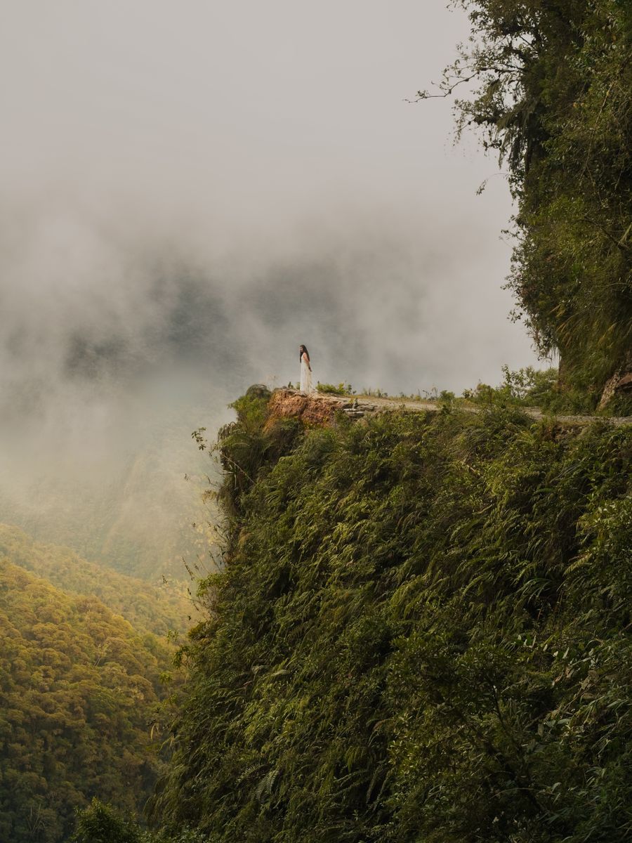
The North Yungas Road (La Cumbre → Coroico) was declared the world's most dangerous road in 1995, with up to 300 annual deaths when it was the only route between La Paz and the Amazon. 64km of dirt ledge road, no barriers, over 600m precipices.
2006
The transformation
The new paved road cut the journey from 6 risky hours to 3 safe ones. The old road became Bolivia's most popular tourist attraction: over 30,000 cyclists descend it each year. Coroico went from a remote settlement to 3 hours from La Paz.

The fact most guides miss: the 2006 paved road didn\'t erase the Death Road — it freed it. Without truck traffic, the old dirt ledge became the most spectacular adventure stage on the continent. Coroico waits at the end: with a pool, cloud forest and the relief of altitude that breathes at 1,760m.

— Things to do in Coroico Bolivia

Six experiences in the cloud forest.

From the Death Road to Afro-Bolivian communities — Coroico has more layers than it appears.

🚵
La Cumbre (4,650m) → Coroico (1,760m)

Death Road Arrival

64km descent · 3,000m drop · cloud forest finish

Coroico is the finish line of the North Yungas Road (Death Road) mountain bike descent — one of Bolivia's most popular adventure activities. The 64km route drops from La Cumbre pass (4,650m) through cloud forest to Coroico at 1,760m. All reputable operators finish in Coroico with a celebratory lunch and bus transfer back to La Paz included.

Local tip
Book the Death Road with operators based in La Paz who finish in Coroico (not operators who stop early at the paved section junction). The Coroico finish adds 15km of the most spectacular riding and the cloud forest arrival. Gravity Bolivia, Barracuda and Altitude Bike are well-regarded operators.
🌿
From town · multiple trails

Cloud Forest Walks

Orchids, bromeliads, hummingbirds · 1,760–2,400m

Coroico has direct access to primary cloud forest from the edge of town. The Sendero Las Cuevas (2–3h loop) passes through moss-covered primary forest with giant tree ferns, dozens of orchid species and near-constant hummingbird activity. The El Mirador trail (1h from plaza) gives panoramic views over the Nor Yungas valley and the Beni lowlands in the distance. For dedicated birding: a local guide from Coroico can record 100+ species in a single morning.

Local tip
Start forest walks by 6:30am — bird activity is highest before the mist burns off. The Las Cuevas trail gets slippery in rain (all seasons); waterproof boots strongly recommended. Local guide Rafael Quispe (ask at any Coroico guesthouse) is the reference for Nor Yungas birding — he has the full valley list and pre-dawn departure spots.
Valleys below Coroico · 30–60 min

Coffee Farm Visits

Bolivian specialty coffee · harvest October–February

The valleys below Coroico (900–1,400m) produce some of Bolivia's best specialty coffee — small farms growing Typica and Caturra varieties at altitude, hand-picked and sun-dried. Several farms near Coroico accept visits: the Finca El Cafetal (45 min below town) offers guided harvest tours (October–February) with picking, processing demonstration and cupping. Coffee quality from this zone routinely scores 85+ points at international competitions.

Local tip
The harvest season (October–February) is the best time for a farm visit — you can participate in picking. Outside harvest season, the beneficio (processing station) visit and cupping are still available. Bolivian coffee is almost entirely exported as green beans — buying roasted coffee directly from farms at origin is one of the best value purchases you can make in Bolivia.
🎵
Tocaña · 20km from Coroico

Afro-Bolivian Communities

500 years of African heritage in the Andes

The Afro-Bolivian communities of Tocaña, Mururata and Dorado Chico are 20–40km from Coroico and represent one of South America's most remarkable cultural survivals — descendants of enslaved Africans brought to work Potosí's silver mines in the 16th century, later relocated to the Yungas for coca and sugar. They maintain a distinct saya music and dance tradition, a communal king institution (Rey Africano), and Nor Yungas Spanish dialect. Tocaña is the most accessible community for respectful visits.

Local tip
Always visit with a guide or advance community contact — unannounced visits are not respectful. Love Bolivia has established community contacts. The best time for a saya performance visit is during community festivals (Santos Inocentes in December, La Candelaria in February). The 20km Tocaña road from Coroico is passable by car (dirt road, 30 min) but requires good conditions.
🏊
Multiple hotels · edge of town

Swimming Pools with Forest Views

Jungle views at 1,760m · subtropical warmth

Coroico has an unusual concentration of guesthouses and small hotels with outdoor swimming pools positioned over the valley edge — swimming at 1,760m with cloud forest on all sides and the Beni lowlands visible 100km away is one of Bolivia's most distinctive experiences. The Hostal Sol y Luna (road above town) and Hotel Esmeralda have the best-positioned pools. Warm enough to swim comfortably year-round.

Local tip
Book accommodation with a pool in advance in July–August (Bolivian winter holiday season) when Coroico fills with pacenian families escaping the altiplano cold. The pools are fed from natural springs — no heating required at this altitude and latitude. Afternoon swimming (3–5pm) after morning forest walks is the classic Coroico day structure.
🌄
Plaza principal · Calle Sagárnaga

El Mirador & Town Life

Panoramic valley views · best markets in the Yungas

The main plaza of Coroico has one of Bolivia's most dramatic settings: a colonial square perched on a ridge with 270-degree views over cloud-forested valleys dropping to the Beni lowlands. The Sunday market (plaza, 7am–1pm) brings produce from surrounding communities: tropical fruits, coca leaves, local vegetables and the best chicha de maíz in the Yungas. The town has an easy walkability — everything within 15 minutes on foot.

Local tip
The mirador above the Coroico cemetery (Cerro Uchumachi, 20-min uphill walk from plaza) gives the best sunset views in the region — the combination of cloud forest, valley depth and late afternoon light is extraordinary. Thursday and Sunday are market days on the plaza — arrive early for the best tropical fruit selection (maracuyá, chirimoya, papaya, cacao pods).
— Travel logistics

3 hours from La Paz.

🚌

How to get to Coroico

  • From La Paz (Villa Fátima): direct bus/minibus, 3h on new paved road, ~20–25 Bs. Frequent departures from 6am.
  • Shared taxi from La Paz: ~50–70 Bs per person, faster.
  • Via Death Road: mountain bike descent with operator from La Paz — finishes in Coroico (5–6h total). Return transfer to La Paz included.
  • From El Alto: 2.5h on new road.
  • No airport in Coroico — all connections are overland from La Paz.
  • From Rurrenabaque: 2 days via Yucumo or small plane to La Paz then road.
🚶

Getting around Coroico

  • The village is fully walkable — everything 10–15 min from the main plaza.
  • Taxi or mototaxi: available on the plaza for community visits, coffee farms and trails (~15–30 Bs).
  • For Tocaña and Afro-Bolivian communities: arrange through guesthouses or local agencies (vehicle needed).
  • Mountain bike rental: available at some plaza agencies (~100–150 Bs/day).
FAQ

Questions about Coroico.

Plan your trip →

Coroico is Bolivia's most popular mountain escape — a cloud forest village at 1,760m in the Nor Yungas of La Paz department, 3 hours from La Paz by new paved road. It has a warm subtropical microclimate year-round, good accommodation and restaurants, direct cloud forest access, the famous Death Road mountain bike finish line, coffee farm visits and Afro-Bolivian communities nearby (Tocaña, Mururata, Dorado Chico).

From La Paz: bus or minibus from Villa Fátima terminal, 3 hours on the new paved road, ~20–25 Bs. Shared taxi: ~50–70 Bs per person. The Death Road mountain bike tour (with any La Paz operator) ends in Coroico with lunch and bus transfer back included. The old Death Road itself takes 4h by car. No flights to Coroico — all access is overland from La Paz.

2 nights is the minimum for a meaningful Coroico experience: day 1 (Death Road arrival or bus arrival + pool + mirador), day 2 (cloud forest walk + coffee farm). 3–4 nights if you want Tocaña Afro-Bolivian community visit, serious birding and the full Taquesi or Choro trailhead access. Coroico is the classic 3-night break from La Paz — the altitude drop from 3,600m to 1,760m alone is a physical transformation.

Coroico has a year-round subtropical microclimate — there is no bad time to visit. May–October (dry season) gives the driest trails and clearest skies. November–April (wet season) brings afternoon rain but mornings remain sunny and the forest is at its most lush and green. July–August is peak Bolivian holiday season and Coroico fills with La Paz families — book accommodation ahead. The Death Road by bike is rideable year-round (muddier in wet season but still operational).

The Death Road (Camino de la Muerte or North Yungas Road) is a 64km mountain road descending from La Cumbre pass (4,650m) to Coroico (1,760m) — a 3,000m vertical drop. It was declared the world's most dangerous road in 1995 (up to 300 deaths per year when it was the main La Paz–Amazon route). Since a new paved road opened in 2006, the old road is used almost exclusively for mountain biking. Over 30 operators in La Paz run daily descents finishing in Coroico.

Yes — the Afro-Bolivian communities of Tocaña (20km from Coroico), Mururata and Dorado Chico are among the most historically significant in South America. Their ancestors were enslaved Africans brought to work Potosí's silver mines in the 16th century and later relocated to the Yungas valleys. They maintain saya music and dance, a communal king institution (Rey Africano), and distinct cultural traditions. Tocaña is the most accessible for visits — always with a guide or advance community contact.

— Plan your Yungas trip

The forest is waiting.
3h from La Paz.

We design your Coroico and Yungas itinerary — Death Road, Afro-Bolivian communities, coffee and cloud forest.

$90 · €85 · Bs. 623

Book consultation → $90 · €85 · Bs. 623Yungas guide →