Bolivia’s oldest national park gets a fraction of the attention it deserves. Sajama was declared a protected area in 1945 — before the concept of national parks had properly reached most of South America — and for eight decades it has sat at the foot of Bolivia’s highest mountain, 230 km west of La Paz, largely undiscovered by the international traveller who comes for Uyuni and the Amazon and never quite makes it to the Oruro altiplano.
That is beginning to change, slowly. And it should, because Sajama offers something the rest of Bolivia’s altiplano circuit cannot: the visual drama of a perfect volcanic cone (6,542 m) rising from a flat plateau at 3,650 m, flanked across the Chilean border by the twin Payachatas volcanoes (Parinacota, 6,348 m; Pomerape, 6,282 m), all three reflected in the bofedal wetlands below on calm mornings.
The Park
Sajama National Park covers 1,002 km² of high-altitude puna in the Oruro department, sharing a 9 km border with Chile’s Lauca National Park. The base elevation of the park floor is approximately 4,200 m — higher than the summit of many alpine peaks in Europe — and the terrain rises to 6,542 m at the Sajama summit. Everything in between is high-altitude desert, bofedal wetlands, lava fields and the slopes of a volcano that has not erupted (by best estimates) in approximately 1,000 years.
Azorella compacta — the living geology: The most surprising thing about Sajama’s slopes above 4,500 m is the colour. The volcanic rock is carpeted in bright chartreuse-green cushion plants — Azorella compacta, locally called yareta — that grow so slowly (approximately 1.5 cm per year) that a specimen 1 metre in diameter is typically 300–500 years old. The larger colonies covering 5–10 square metres are estimated to be 2,000–3,000 years old — living organisms that pre-date the Inca Empire on the same patch of ground. Walking among them without stepping on them requires attention; stepping on them destroys centuries of growth.
Bofedales: The flat basin around Sajama village is threaded with bofedales — high-altitude peat wetlands that act as natural water storage, fed by glacial melt and geothermal seepage. They are chronically green even in the driest months and support a disproportionate density of wildlife for the altitude. Flamingos — all three Bolivian species, James’s, Andean and Chilean — feed in the shallower sections. Andean geese nest at the margins. Viscachas (high-altitude chinchilla relatives) sun themselves on bofedal edges. Vicuñas graze the drier slopes above.
Condors: The Sajama plateau is among Bolivia’s most reliable locations for Andean condors. The thermals off the volcanic rock attract them consistently in the late morning. A patient hour at the mirador above the village in conditions of moderate sun and light wind will typically produce multiple sightings.
The Village of Sajama
The Aymara community of Sajama village has approximately 200 residents and has developed one of Bolivia’s better-organised community tourism systems. Visitors can book:
- Homestays (Bs 60–100/night including meals) with local families — food is altiplano cooking: quinoa soup, freeze-dried potato (chuño), llama and alpaca meat. Not elaborate, but genuinely prepared and generous.
- Guided circuits in 4WD including the hot springs, the volcano viewpoints and the bofedales. A full-day 4WD circuit costs approximately Bs 250–300 for the vehicle (shared among passengers).
- Climbing guides for the Sajama summit — licensed local guides who know the standard route (south face) and the crevasse patterns on the Sajama glacier. Day rate approximately USD 80–100.
The community charges a park entrance fee of Bs 30 per person collected at the village entrance. There is no ATM in the village — bring cash from La Paz or Oruro.
The Hot Springs
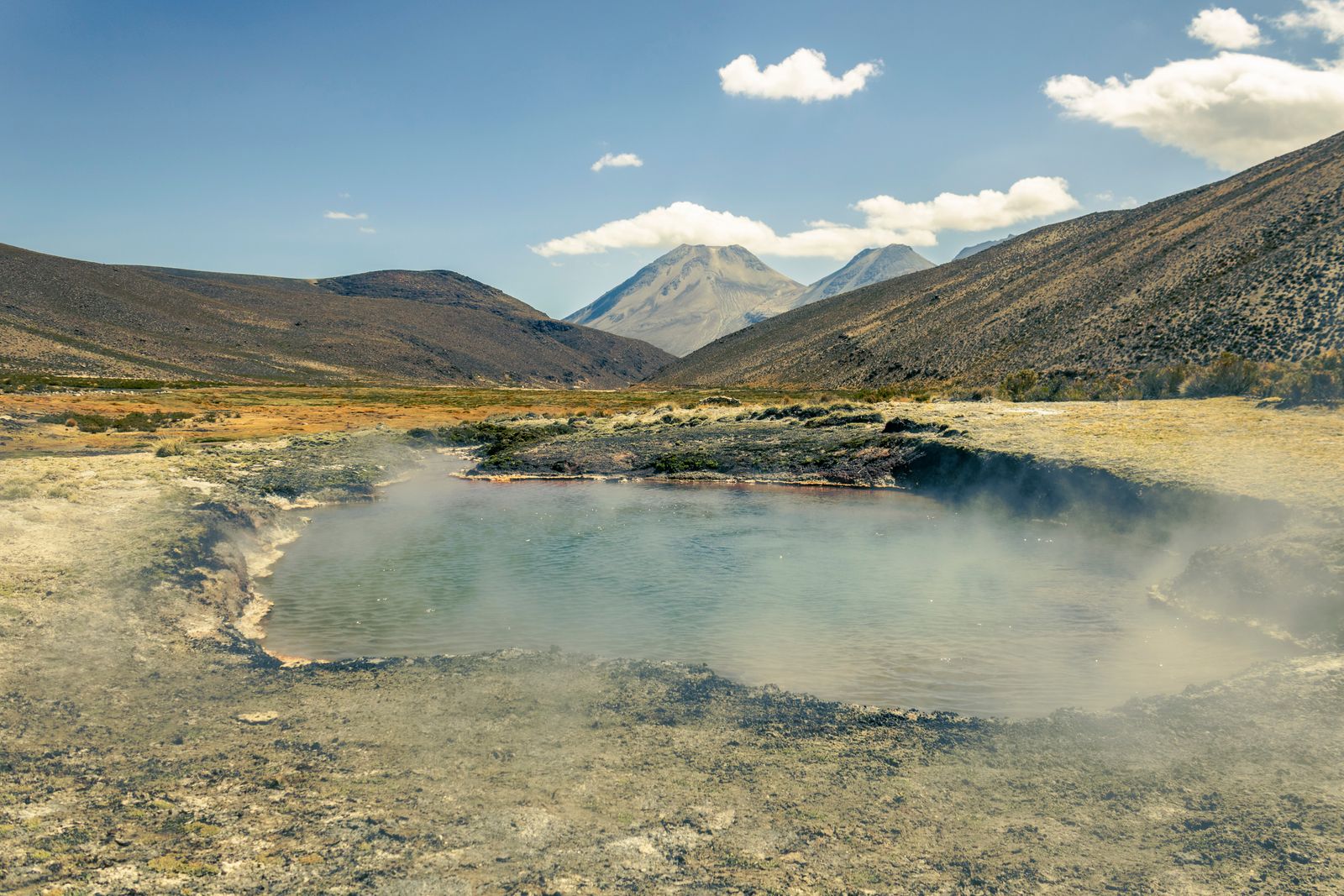
Seven kilometres from the village by 4WD track (or 2 hours on foot), the Aguas Termales de Sajama are among the most atmospheric thermal pools in Bolivia. Geothermally heated water (the Sajama volcanic system is still thermally active even if not erupting) surfaces at 38–42°C in the hotter pools and around 28°C in the cooler overflow channels.
The setting: steam rising from three small pools cut into the ground, the Sajama cone visible above at 6,542 m, complete silence except for the wind across the puna. Entry is Bs 20 per person, managed by the community. There are basic changing facilities and a small shelter. Bring your own towel. Arrive before 10am for the best light and least wind.
The springs are accessible by 4WD from the village in approximately 20 minutes. Walking is possible on the marked path but takes 2 hours each way at altitude — budget accordingly.
Climbing the Summit
The Sajama summit (6,542 m) is Bolivia’s highest point and a genuinely serious mountaineering objective. Unlike Huayna Potosí (6,088 m, accessible to guided beginners), Sajama requires:
- Technical glacier travel with crampons and ice axe
- Rope work for crevasse avoidance on the upper snowfield
- Acclimatisation to at least 5,000 m before the summit attempt (minimum 3 days in the park)
- A SERNAP permit (obtainable through the village administration, approximately USD 50)
- A licensed local guide (required; not optional)
The standard route ascends the south face and takes 7–10 hours from high camp (5,200 m) to summit, plus 4–6 hours return. High camp is established on the second or third day after arrival. Total time for a realistic summit attempt: 5–7 days from La Paz including acclimatisation.
The summit panorama justifies the effort for those with the skills: the entire southern Andes spread across four countries, the Chilean desert to the west, the Bolivian altiplano to the east, and on a clear day, peaks in northern Argentina to the south.
When to Visit
May–September (dry season): The recommended window for all activities. June–August has the most stable weather and the best conditions for condor and flamingo sightings (flamingos concentrate in the bofedales when the high lakes of Lauca across the border are frozen). The summit is best June–August when the snowpack is consolidated.
October–April: The southern hemisphere summer brings afternoon thunderstorms to the altiplano. The park is accessible but the hot springs road can flood, summit conditions are less predictable, and the bofedales are at their greenest and most photogenic. Good for landscape photography; not recommended for summit attempts.
Night temperatures: Year-round, temperatures at Sajama village (4,200 m) drop to -5°C to -15°C at night, and to -20°C or below on the summit plateau. A sleeping bag rated to -15°C minimum is essential even in July.
Practical Information
Getting there: La Paz (Terminal Terrestre) → Patacamaya by bus (2 hours, Bs 15, frequent departures). Patacamaya → Sajama village by shared taxi or minivan (1.5–2 hours, Bs 30–50 per person). Total: 3.5–4 hours. A direct 4WD rental from La Paz takes approximately 3 hours on sealed road to Patacamaya, then gravel track to the village.
Accommodation: Homestays with local families (Bs 60–100/night full board). There are also two small basic guesthouses in the village. No hotels of international standard — that is the point.
What to bring: Sleeping bag rated -15°C minimum, sun protection SPF 50+ (UV index 15–20 on the altiplano), windproof outer layer (wind at 4,200 m is relentless), plenty of cash (no ATM), snacks for the hot springs excursion, and trekking poles if you plan any walking on the bofedales.
Combining with Chile: Sajama is 30 km from the Tambo Quemado–Chungará border crossing. Chile’s Lauca National Park (home of Parinacota and Pomerape, the blue Lago Chungará at 4,517 m, and one of the world’s densest vicuña concentrations) begins immediately on the other side. A Bolivia–Chile combined visit is logistically feasible in a 4WD hired from La Paz or Arica.
Key facts
- → Sajama volcano reaches 6,542 m — the highest peak in Bolivia and one of the highest in the Andes south of Peru.
- → Sajama National Park was established in 1945, making it Bolivia's oldest national park; it covers 1,002 km² in the Oruro department near the Chilean border.
- → Azorella compacta (yareta), the bright-green cushion plant that covers Sajama's slopes above 4,500 m, grows approximately 1.5 cm per year — specimens covering 1 m² are typically 300–500 years old; those covering 10 m² may be 3,000+ years old.
- → The park hosts all three Bolivian flamingo species — James's (Phoenicoparrus jamesi), Andean (Phoenicoparrus andinus) and Chilean (Phoenicopterus chilensis) — in the bofedal wetlands.
- → From Sajama village, the twin volcanoes of Parinacota (6,348 m) and Pomerape (6,282 m) are visible across the Chilean border in Lauca National Park — one of the Andes' most dramatic mountain panoramas.
Frequently asked questions
Can beginners climb Sajama volcano? +
No. The Sajama summit (6,542 m) requires technical mountaineering skills: crampons, ice axe, rope work, crevasse rescue knowledge and acclimatisation to at least 5,000 m before attempting. It is significantly more technical than Huayna Potosí. A permit from SERNAP (Servicio Nacional de Áreas Protegidas) is required. Most climbers hire guides from Sajama village and take 3–5 days for the acclimatisation–summit cycle.
How do I get to Sajama National Park from La Paz? +
Take a bus from La Paz (Terminal Terrestre) toward Tambo Quemado or Arica (Chile) — all these buses pass through Patacamaya (2 hours, Bs 15). From Patacamaya, shared taxis and occasional minivans go to Sajama village (1.5–2 hours more, Bs 30–50). Total journey: approximately 3.5–4 hours. A direct 4WD from La Paz takes about 3 hours.
What are the Sajama hot springs like? +
The Aguas Termales de Sajama are geothermally heated pools at approximately 4,200 m, located 7 km from the village by 4WD track. Water temperature varies by pool: the hottest reach 38–42°C, the coolest around 28°C. The experience of soaking in 40°C water at 4,200 m with the Sajama cone directly above is genuinely unusual. Entry costs approximately Bs 20 per person; the facility is run by the Sajama community.